


Nebraska Thunderstorm Eye Candy 018
by NebraskaSC


Title
Nebraska Thunderstorm Eye Candy 018
Artist
NebraskaSC
Medium
Photograph
Description
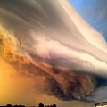
May 15, 2017 - South of Holdrege Nebraska
Moderate Risk threat that afternoon as the storm began to fire about 5pm CDT in south central Nebraska.
We had planned it out perfectly. Just out in front of these cells before the NWS through a warning on this supercell. We didn't have much time though as it was producing golf ball sized hail just to the west of our location.
Uploaded
May 19th, 2017
Statistics
Viewed 22 Times - Last Visitor from New York, NY on 01/13/2024 at 10:15 PM
Embed
Share
Sales Sheet
Similar Images


Comments
There are no comments for Nebraska Thunderstorm Eye Candy 018. Click here to post the first comment.
Recently Viewed
