


Northern Kansas Southeast Nebraska Chase Day 004
by Dale Kaminski


Title
Northern Kansas Southeast Nebraska Chase Day 004
Artist
Dale Kaminski
Medium
Photograph
Description
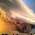
June 9, 2020 - Northern Kansas
A 10% tornado risk day when the SPC maps were out early in the morning on this day. Models had favorable for late afternoon severe storms to erupt right on the Nebraska Kansas Border.
Had been chasing storms past few days and the wear on the body was at hand. With this rare opportunity in 2020, a year of no tubes, we didn't want to miss this tornado event in my backyard if it happened. Sucked up the tiredness and snagged my chase partner in Hastings Nebraska and headed south into North Central Kansas. The prime of the predicted storm zone for that afternoon.
After the first storms initiation, we were watching out west with good development to our west... Mankato Kansas. Everything was moving almost due northeast that afternoon and we thought we could cut north and follow the storm cell that had the most promise of development.
On target and in position to intercept just to the south of Reynolds Nebraska we had our first Tornado of the year.
Incredible bands of winds around this tornado was kicking up so much dust that it was almost haboobish.
After this encounter we headed back to the northeast to intercept again then back down to Nebraska Hwy 136 to Beatrice. All in all, we followed that same system till it merged with another cell. We followed the system eastward as the warnings stayed active. We did see a few wall clouds and funnel bases that afternoon but nothing as good as what we caught in Reynolds Nebraska. Not a bad way to end another epic storm chasing day!
Uploaded
June 29th, 2020
Statistics
Viewed 19 Times - Last Visitor from New York, NY on 11/12/2023 at 10:05 PM
Embed
Share
Sales Sheet
Similar Images


Comments
There are no comments for Northern Kansas Southeast Nebraska Chase Day 004. Click here to post the first comment.
Recently Viewed
