


Red Cloud Nebraska Supercell 005
by NebraskaSC


Title
Red Cloud Nebraska Supercell 005
Artist
NebraskaSC
Medium
Photograph
Description
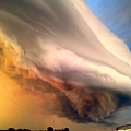
July 15, 2015 - South of Red Cloud Nebraska US
Right on the Nebraska / Kansas Border
NWS had the severe weather events for that day were to be about 200 miles to the east of south central Nebraska. Though we still had a risk of severe weather, but with the 100 Temps and lots of moisture to work with... it was bound to happen.
Finally, after waiting for a extremely slow train crossing Hwy 136 west, we were able to get south of Red Cloud Nebraska. Met up with some other chasers and we all were going to go follow the leading severe warned cells in central Kansas. Low and behold the cell just south of Red Clouds had just went into a warning. Can you say right place.... Right Time!
This was simply the best structured cell that I have caught up this season for tornadic activity. This cell did not produce a tornado, but it had rotation, hail, and torrential rain. Eye Candy for the Storm Chaser in mind....
Uploaded
July 20th, 2015
Statistics
Viewed 20 Times - Last Visitor from Fairfield, CT on 03/29/2024 at 12:05 PM
Embed
Share
Sales Sheet
Similar Images


Comments
There are no comments for Red Cloud Nebraska Supercell 005. Click here to post the first comment.
Recently Viewed
