Sale on canvas prints! Use code ABCXYZ at checkout for a special discount!

Boundary: Bleed area may not be visible.


by NebraskaSC
$30.50
Size
Orientation
Image Size
Product Details
Our luxuriously soft beach towels are made from brushed microfiber with a 100% cotton back for extra absorption. The top of the towel has the image printed on it, and the back is white cotton. Our beach towels are available in two different sizes: beach towel (32" x 64") and beach sheet (37" x 74").
Don't let the fancy name confuse you... a beach sheet is just a large beach towel.
Design Details
July 17, 2015 - South of Ansley Nebraska... more
Care Instructions
Machine wash cold and tumble dry with low heat.
Ships Within
1 - 2 business days
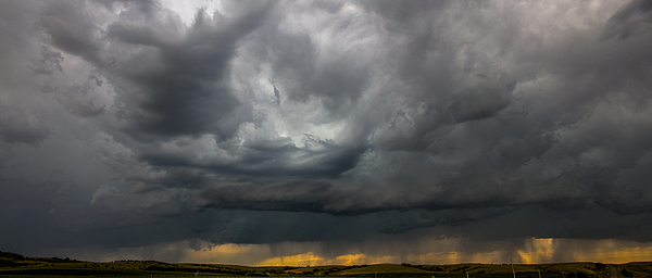
July 17, 2015 - South of Ansley Nebraska
Was quite surprised to see storms develop out in the western part of Nebraska that day. The cold front had pushed into the state by early afternoon and severe storms were forming. Severe weather watches were posted for Dawson and Custer counties. Storms were moving at 10mph and I had plenty of time to catch up to them from Kearney.
Just south of Ansley Nebraska, this particular cell was under a severe thunderstorm warning and there was good development off to the north and west. Though I was on the outer edge of the north severe cell I pulled off and got a few good captures.
NebraskaSC = Nebraska Storm Chaser I've been chasing storms since the early 80's, out in the plains of Nebraska. A passion to capture the moments that mother nature brings every spring summer and fall to South Central Nebraska. Yes I chase the storms, but I don't travel all that far to get these superb captures of natures fury. I seem to have a knack to be in the right place at the right time. I'm not egotistical, my photography is an extension of what I call art. Since I cannot draw, or paint, but I can get to the right place at the right time when severe weather approaches. These are a collection of my doing so.
$30.50


There are no comments for Mid July Nebraska Thunderstorms 001. Click here to post the first comment.